ARLINGTON, Texas—After logging in 17 miles in under three hours according to his Apple watch, Arlington resident Mark List received a phone call from his wife. She wanted him to pick up a loaf of bread before he headed home, he said.
The nearest convenience store, Race Trac, was a quarter mile away off South Cooper Street and West Mayfield Road. As List headed up West Mayfield around 4 p.m., he approached a red light at the intersection, where he awaited the pedestrian crosswalk signal.
List wiped sweat off his forehead and took a swig of water to cool down. It was another sizzling July 2019 day. As the signal changed, List began pedaling when a beat-up white Dodge Durango ignored the signal, cutting off List. He tumbled toward the steaming pavement.
“I knew I was going to fall,” List said. “It was either that or pedal straight and risk a head-on collision with the Durango. Those scrapes and bruises would heal in days. I’m not sure how long it would’ve taken me to heal if I pedaled forward.”
Instead of rendering aid, the driver of the Durango sped off. Other drivers and nearby pedestrians rushed to check on List. Luckily for him, he was wearing a helmet.
“I was startled, but fine,” List said. “I made it back home to my wife with the loaf of bread and added an extra mile before ending my cycling time.”
***
In 2009, Arlington began drafting its Hike and Bike plan with the vision of improving resident mobility and promoting health and wellness. The plan was developed as a collaboration that included city staff, key stakeholders and physically active residents.
The final plan was adopted by City Council in 2011, according to city documents. Planning was necessary considering the city’s population was nearing 400,000 residents, making Arlington the 49th largest city in the U.S., according to the Census Bureau.
The plan connects comprehensive routes, reduces traffic and promotes safe pedestrian crossings among other positive effects. The plan was committed to offering residents a healthy lifestyle and affordable personal mobility, city leaders and residents said.
In a 2023 summary report, Arlington was named the 58th fittest city out of 100 cities in the U.S., according to the American Fitness Index. AFI ranks cities on health behaviors, community infrastructure and local policies that support a physically active lifestyle.
The Centers for Disease Control and Prevention recommends 150 minutes of moderate-intensity aerobic activity each week and muscle-strengthening activities twice a week. Factors that determine bike-friendly cities include the number of protected bike lanes present in the city, safe speeds and reallocated space for biking and walking.
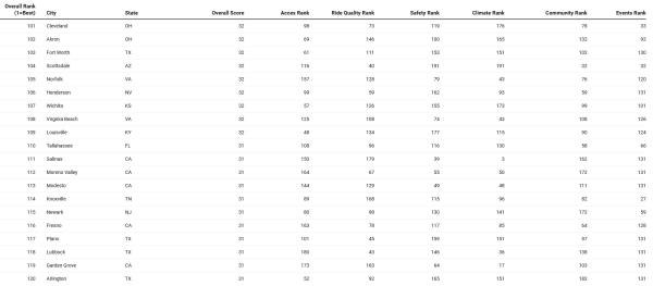
According to a 2023 analysis by LawnStarter, Arlington ranked No. 120 out of 200 U.S. cities in terms of its friendliness to biking. Cities are ranked in five categories, which include access, ride quality, safety, climate and community.
City of Arlington principal planner Jana Wentzel said the city coordinates with the parks department and public works on constructing changes while it continues its weekly meetings to hear ideas and feedback from residents. There’s no expiration date to the long-term plan.
The Transportation Department oversees plans, and the city adjusts as needed, Wentzel said. Guidance is then provided in seeing which roads are slated for bike construction.
Determining how often accidents and fatalities occur is an issue that the city is constantly looking at, Wentzel said. To improve road safety, the city gets funding from the U.S. Department of Transportation to complete the Safety Action Plan.
In 2015, the North Central Texas Council of Governments launched its “Look Out Texans” campaign. North Texans are encouraged to care for one another on the road to promote walking, biking and driving safety. Funding is provided by the Texas Department of Transportation.
Transportation planner Catherine Richardson said part of the reasoning behind the campaign was due to the rise in fatalities involving pedestrians and cyclists. The program provides safety tips such as eye contact and safer road behaviors between pedestrians, cyclists and motorists.
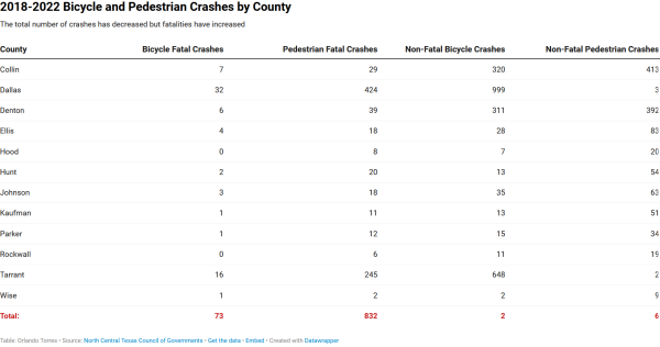
NCTCOG pulls its crash-reporting information from TxDot. NCTCOG uses the information to monitor crashes and fatalities. If multiple people riding together are involved in a car it will count as one crash or fatality, Richardson said.
“The total number of crashes has decreased, but the number of fatal crashes has increased,” Richardson said. “We’re seeing less crashes, but the fatality rate has gone up.”
Department of Public Works City Traffic Engineer Chris Funches said TxDot determines which areas should be prioritized when comparing populated areas like downtown Arlington and the area around the University of Texas at Arlington, which are seeing a rise in development.
High-maintenance streets include Cooper, Mitchell and UTA Boulevard, all of which have seen conflicts between cyclists and motorists, Funches said. Technology helps determine which intersections need improvement and will determine which streets could be safer.
Public Works frequently visits with groups such as Walkable Arlington, neighborhood associations and surrounding entities in the entertainment district to hear concerns about pedestrian and cyclist safety, Funches said.
***
After his incident with the Durango, List said he stayed away from cycling for a few weeks but did invest in more protective gear. He now meets with other cyclists in his community to spread awareness when riding in busy areas.
In addition to spreading awareness, the biking community attends city meetings and creates petitions, List said. He added that Arlington is a beautiful city with places to explore, such as River Legacy Park, but it’s dangerous if both cyclists and motorists aren’t doing their part on the road.
Wentzel said the city has placed a renewed emphasis on vulnerable road users. In prior years, Public Works would keep track of certain issues, but now the city has multiple departments when designing and constructing roads because funding is provided for in-depth analysis.
An issue several cities face is meeting the demands of a growing population, Richardson said. For example, there’s been a rise in crashes between cyclists and pedestrians.
To meet the demands, analysts use forecasting models to determine which areas are seeing the most growth, Richardson said. NCTCOG stays up to date by attending conferences and webinars to develop sustainability.
The goal is to prove safe transportation for all users, Richardson said. NCTCOG works as a public resource consultant in providing funding opportunities to cities and counties to help promote projects providing safer facilities and accommodations for cyclists and pedestrians.
Factors that go into the width of a bike lines include volume, level of separation and speed around the roadway, Richardson said. NCTCOG follows the guidelines from the Texas roadway design manual.
At the regional level, NCTCOG advocates for cities to implement bikeways that are accessible for all ages and abilities, Richardson said.
Funds are funneled from the federal government to Txdot to NCTCOG, which is then allocated and provided to projects in the region, Richardson said. Grants are also available for cities.
Whenever there’s a bond project or a major roadway improvement, Public Works will hold public meetings to answer safety-related questions, Wentzel said.
Recently, a bond proposal passed that included the Village Creek trails and improvements to Mansfield Webb Road. Current developments include Mansfield Webb Road and Julia Burgen Linear Park, where trails are being implemented that didn’t have connectivity in the past for cyclists, Funches said.
Most trails are completed for cyclists and pedestrians to explore, Wentzel said. A few uncompleted gaps remain but will be completed within two years.
With cycling gaining more popularity, the challenge is keeping students safe when away from campus, Wentzel said. Because UTA owns certain roads around campus, there’s a lot of coordination between the city and campus to keep students safe.
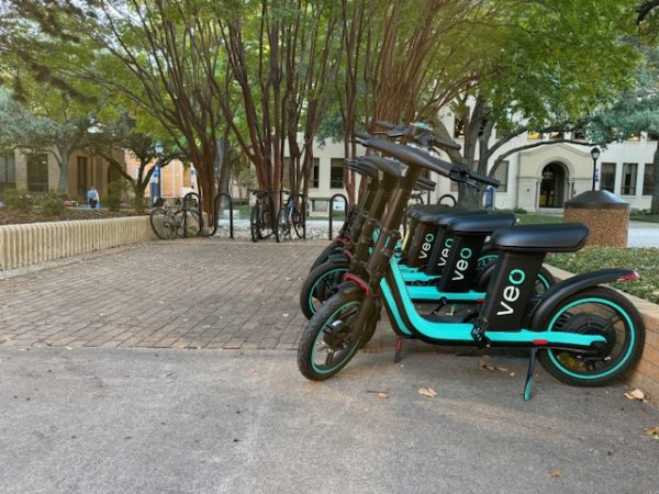
Safety measures might include lanes, shared pavements and marking signage. Public works will also send capital projects to TxDot for review and recommendations before changes are implemented, Funches said.
Public Works follows federal and TxDot guidance on determining how much space should be given to bike lanes, Funches said. If there’s not enough roadway to add a bike lane, the city creates 10-foot, shared-use paths for cyclists to ride on, Funches said.
When pavement markings are needed to delineate bike lanes and shared bike paths, public works will mark roadways, Funches said. Technology at intersections is also used to identify cyclists and pedestrians in comparison with motorists and will give feedback on how traffic is operating.
One challenge in tracking safety campaigns is discovering the positive effects, Richardson said. It’s difficult finding out how effective its messages are in the public, but NCTCOG continues to target the public by promoting safety tips, educating the public on the law and engaging with audiences through social channels.
“At the regional level, we are trying to be a resource to Arlington and other cities that are within our region,” Richardson said.
NCTCOG will continue to work with its partners to provide educational materials and spread positive messaging in getting everybody involved to promote safe cycling, Richardson said.

